Why I-73/74 in North Carolina?
Introduction
Interstates 73 and 74 were initially authorized by the Intermodal Surface Transportation and Efficiency Act (ISTEA) of 1991, as one of several high priority transportation corridors to be designated across the country. The I-73/74 corridor, Corridor 5 as defined by ISTEA, and in later amendments to that act including the Transportation Equity Act for the 21st Century of 1996 (TEA-21), defined both the routing of a new Interstate 73 through Michigan, Ohio, West Virginia, Virginia, and North and South Carolina and the extension of already existing Interstate 74 between Cincinnati, Ohio, and South Carolina.1 Lobbying to include this route, initially described as a Detroit to Charleston interstate, as a High Priority Corridor in the 1991 Act was encouraged by many business and transportation groups as a way both to enhance economic development potential throughout the corridor and as a means to encourage funding many previously existing highway upgrade projects along the path of the proposed highways.2
Initially the corridor was to be served by one interstate, I-73, but when officials in Virginia, including newly designated chairman of the Senate transportation subcommittee John Warner, sought a more eastern path for the new corridor through Roanoke disputes arose over the proposed routing, especially in the Carolinas (both Greensboro and Winston-Salem wanted the new interstate in North Carolina, South Carolina feared the interstate would end in Wilmington and not benefit the South Carolina coast). A compromise was reached between Senator Warner and Senator Lauch Faircloth of North Carolina in 1995 whereby I-74 would be extended from Cincinnati and serve as a seperate route where disputes over the path of I-73 existed. I-74's route would serve Winston-Salem and I-73 Greensboro (critics claimed at the time that Faircloth's support for the I-73 route through Greensboro was aided by a major donor to his campaign, the Jefferson Pilot Insurance company having land along the future I-73 route). Later Faircloth and Senator Strom Thurmond of South Carolina reached a compromise over the where the two routes would enter the Palmetto State. I-73 was promised to enter South Carolina near Rockingham while the I-74 corridor would enter south of Wilmington.3
Though the routes were approved by Congress, no money was appropriated to pay for any construction. It was left up to each state to decide when, and if, I-73 and I-74 were to be built. Later the termini for the I-73 corridor was changed to run from Sault Ste. Marie, Michigan to Georgetown, SC. For more on the proposed routings of I-73 and I-74 beyond North Carolina go to the AARoads High Priority Corridor 5 Page.
On July 25, 1996, AASHTO accepted Interstate 73 and the Interstate 74 into the Interstate Highway System within the states of South Carolina, North Carolina, and Virginia. The approved route for I-73 was from the I-81/ I-581 intersection in Roanoke, Virginia south to the intersection of US 17 and I-26 in Charleston, SC. The southern terminus was later truncated to US 17 at Georgetown, SC. For I-74 the route approved was from the more northern of the two intersections of I-81 and I-77 near Wytheville, Virginia to the I-73/I-74 junction near Myrtle Beach, South Carolina.1 In 1997, North Carolina took the lead in signing these two interstates along some of its highways. 2022 marked the 25th year anniversary of their signing.
I-73/74 in North Carolina
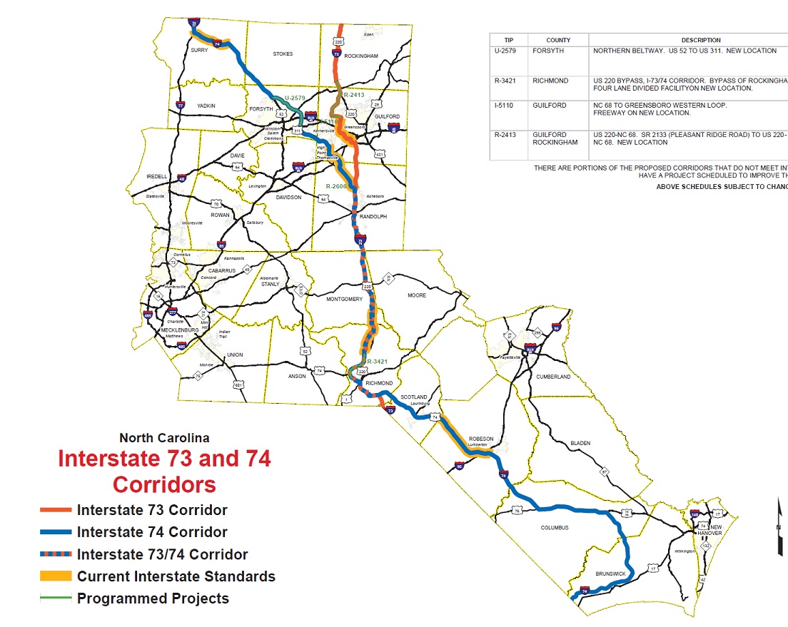
NCDOT planned Interstates 73 and 74 to use a combination of mostly existing highways with some sections of new roadways to make their way through North Carolina. I-73 would roughly parallel current US 220 from Virginia to Rockingham and then US 1 (later US 74 east then the path of NC 38) into South Carolina. I-74 would enter with I-77 from Virginia and then roughly follow US 52 to Winston-Salem, then heading east by picking up US 311 to US 220 north of Asheboro, then following it (and I-73) south to US 74 in Rockingham, then finally proceeding east on US 74 to Whiteville then south into South Carolina. A revised 2015 NCDOT map of the proposed routings of I-73 and I-74 by NCDOT is below, it shows the changes to the entry point of I-73 into South Carolina agreed upon in 2005 (and now reflects the revised routing of I-73 around Greensboro approved by the FHWA in 2011)(4):
If fully constructed as proposed, I-74 would be North Carolina's second
longest interstate, totaling about 300 miles*, trailing only I-40's 420
miles but ahead of I-85's 233 miles. I-73 would be the fourth longest at
about 140 miles, beating out I-77 (105 miles) and I-26 (71 miles). While further I-73 construction is
on hold for now. There is continued progress in constructing I-74, with
three distinct segments of I-74 currently signed as full interstate as
of December 2024 totaling almost 132 miles, with 14 miles (12 miles signed as NC 74, and 2 miles of
US 52) unsigned but interstate standard with 4 more miles under construction. The completed
sections of I-73 signed as a full interstate (US 220 freeway north of
Greensboro, the NC 68-US 220 Connector, the I-73 Connector/Bryan Blvd.,
the Greensboro Loop, US 220 south of Greensboro, and the newly completed
Rockingham Bypass) total 107 miles with an additional 12 miles near Rockingham unsigned
but up to interstate standards. Percentage-wise, however, since I-73 is
much shorter, more of I-73's routing is completed to interstate
standards (86%) than I-74's (48%).
Status of I-73 and I-74 as of March 2025:
 Though little expansion of I-73 occurred in the
decade after the road was first signed in 1997, since 2009 progress on
building I-73 has been significant. The years 2009 and 2010 saw several
critical achievements in the Greensboro area, including I-73 replacing
I-40 as the primary route on the SW section of the Greensboro Loop and
the highway now designated I-73/US 421 and Bryan Blvd. classified as an
National Highway System Route, allowing I-73 to be routed north of I-40
along current Future I-840. Both I-73 and I-840 were accepted into the
interstate system in August 2011. Elsewhere along the corridor, the
upgrading of US 220 through Asheboro, a project started in the fall of
2009, was completed in October 2012. NCDOT then changed the exit numbers
along this section to reflect I-73's mileage. A related project replaced
exit signs as well as numbers from Ulah to Emery was completed in
October 2013. The contractors also updated the route with full
interstate shields by December 2013, allowed by the FHWA once the
Asheboro project was completed.
Though little expansion of I-73 occurred in the
decade after the road was first signed in 1997, since 2009 progress on
building I-73 has been significant. The years 2009 and 2010 saw several
critical achievements in the Greensboro area, including I-73 replacing
I-40 as the primary route on the SW section of the Greensboro Loop and
the highway now designated I-73/US 421 and Bryan Blvd. classified as an
National Highway System Route, allowing I-73 to be routed north of I-40
along current Future I-840. Both I-73 and I-840 were accepted into the
interstate system in August 2011. Elsewhere along the corridor, the
upgrading of US 220 through Asheboro, a project started in the fall of
2009, was completed in October 2012. NCDOT then changed the exit numbers
along this section to reflect I-73's mileage. A related project replaced
exit signs as well as numbers from Ulah to Emery was completed in
October 2013. The contractors also updated the route with full
interstate shields by December 2013, allowed by the FHWA once the
Asheboro project was completed.
Construction to build a new connector freeway to take I-73 from NC 68 to US 220 near Summerfield started in 2014 along with the freeway to connect NC 68 to Bryan Blvd. Construction of that project was moved up from 2016 in June 2013 and both were completed by the summer of 2017. In connection with that project, the widening of US 220 south of NC 68 to the site of the connector freeway began in April 2012, and was completed in March 2018. At the southern end, the completion of upgrading 3 miles of US 220 to Interstate Standards as the first part of the Rockingham Bypass project (with I-74) was completed in June 2018. I-73 and I-74 were officially extended along the completed highway in October 2018. Work on the second segment of the US 220 Rockingham Bypass, also carrying I-74, started in January 2020 and was finished in January 2025. With the completion of the second part of the Bypass project, I-73 is now signed all the way from NC 68 north of Greensboro (Exit 123) to just west of Rockingham at US 74 (Exit 16), a total of 107 miles. This is the last I-73 project that is currently funded however, the remaining projects to carry the road north to Virginia and south to South Carolina are unfunded and have no start date.
As for other states, SC has been going back and forth in building I-73.
Approval to build its northern section of I-73 which will connect to US
74/Future I-74 near Hamlet and a funding source was approved to build an
interchange at I-95 in Dillon with the route connecting to US 501 in
2014, but was then tabled. Efforts started again in 2017 when
environmental approvals were obtained, but needed funds need to be
acquired and more lawsuits to prevent the project need to be settled.
While many lawsuits have been settled in the early 2020s, the search for
funds goes on. In November 2024 Horry County will vote on a measure
called Ride 4. It’s a 1% local sales and use tax, or “transportation
tax,” and will be used to complete a list of improvement projects
established by the Ride 4 Sales Tax commission, that includes I-73 for
up to 25 years. There's also a referendum that commits the county to
match 1/2 the cost of building I-73 from SC 22 to the Horry County line
provided SCDOT pays for constructing the interstate from the Horry
County line to I-95. Even if these pass, it would still be several years
before anything is built.5
Meanwhile in VA, the I-73/74 Association announced in October 2008 that
NCDOT had completed right-of-way purchases to upgrade US 220 to an
interstate north for Greensboro to the VA state line. Work will likely
not start until Virginia begins construction of its own section. A new
route for I-73 around Martinsville was approved by VDOT and was approved
by the FHWA in 2012, however no progress on financing the route was ever
made. In 2017 a bill was passed by the Virginia Assembly to use funds
currently collected to construct a 4-lane US 58 across the state to be
switched to I-73 when that work is finished. The legislature, though,
had to vote for the bill again in 2018 for it to become law, and took no
action. In July 2024 the Commonwealth Transportation though voted to scrap the
official I-73 route around Martinsville to Roanoke, killing I-73 in that
state for the time being. Supporters of I-73 hope to have it rerouted on
a new bypass called the Southern Connector west of the city. If
approved, a new Environmental Impact Statement would have to be made and
then money would still be needed to build the road and a connection to
I-73 in NC, meaning any construction is years off. The presentation
on I-73 at the July 2024 CTB Meeting starts on page 29.

Like I-73, progress on completing I-74 has been steady over the past 20 years. The last leg of the High-Point "East Belt" extension, from then Business I-85 (now US 29) to I-85 which had started construction in late May 2007, along with the first half of the '311 Bypass' from I-85 to Spencer Road, were completed in November 2010. The entire route from Main Street (former Business 311) in High Point east to Cedar Square Road in Glenola was signed I-74/US 311 upon completion. Construction on the remaining section of 'US 311 Bypass' freeway started in early September 2008. Most of the major work constructing the bridges for intersecting roadways and the interchanges with current US 311 in Sophia and US 220 in Randleman had been completed by the end of 2012, however the section was not finally completed until June 7, 2013. NCDOT got permission to sign US 311 east of I-40 in Forsyth County as I-74 in April 2013, however signs indicating this change were not placed until August 2014. With the completion of the last section of the Rockingham Bypass in December 2024, I-74 became continuously signed from I-40 east of Winston-Salem to the end of the US 74 Rockingham Bypass just east of the city of Hamlet, a total of 110 miles. The other completed sections run from I-77 at the Virginia border to US 52 at Mt. Airy for a total of 17 miles, and from Alt. US 74 east of Laurinburg to NC 41 east of Lumberton for a total of 19 miles, giving a total I-74 mileage now for NC of 136 miles.
The major I-74 construction project now underway (with the completion of the Rockingham Bypass project with I-73), is the Winston-Salem Northern Beltway. Work began on the first leg between former Business 40, now the US 421 Salem Parkway and US 158 in the fall of 2014 and the road opened to traffic in early September 2020. Work on the next section from US 158 to US 311 began in January 2018 and was completed in November 2020. A design-build contract to build the remaining part of the Eastern section west of US 311 started in May 2018, and work was completed To NC 66 in November 2022. Meanwhile, construction continued on another design-build contract to build the future interchange between the Beltway and US 52/Future I-74 at NC 65. Work to finished in November 2023 connecting the Beltway with US 52, while work to complete the remaining ramps to continued into late 2024. At the eastern end, work to connect the Beltway at US 421 with I-40 east of Winston-Salem started in January 2022. The last section from I-40 to existing I-74 was let during the summer of 2022, work starting that fall. Both are planned to be completed at the same time in late 2026. Though work to upgrade the segment to the north, US 52 has not been funded, exit numbers to match I-74 mileposts are to be installed in the first half of 2025 as part of the last Beltway contract.
East of Rockingham, NCDOT announced in August 2018 that it would fund upgrading of US 74 between the Rockingham and Laurinburg bypasses with construction to start in 2029, though that project is now no longer funded. Further east, NCDOT is now funding the piecemeal upgrading of US 74 between NC 41 near Lumberton and US 76 west of Whiteville. Intersections along US 74 between Lumberton and Whiteville are being upgraded to interchanges, the first two in 2012. NCDOT signed these two exits using I-74 mileage, along with all other existing exits along the current US 74/76 Whiteville Bypass. Other projects, to build a bridge over US 74 closer to Whiteville was completed in 2017, three other projects to replace intersections with interchanges in Boardman and Evergreen, started between 2018 and 2022, were completed by 2024. Further work, including replacing the intersections with NC 150 and NC 72 with one interchange, and creating a new interchange in Lake Waccamaw along US 74/76 started in 2023, the Lake Waccamaw exit opened in the fall of 2024. There are no funds, however, for any other I-74 projects east of I-95 at this time (though, curiously, there is a now started "Future I-74" project underway near Delco, outside the official path of I-74, for more information see I-74 Segment 19).
For a more detailed listing of the progress made in constructing each Interstate, choose the buttons below, left for the I-73 progress page or right for the I-74 page (or center to go back).
Summary of I-73/74 Progress
In 2004 NCDOT thought I-73 could be signed as a full interstate south of Greensboro to just north of Rockingham by 2010 and that much of I-74's route could be completed by 2014.6 Financial realities caught up with NCDOT though and projects were either moved back or remained unfunded between 2004 and 2015. An uptick of construction since then has brought I-73 signed between NC 68 north of Greensboro and US 74 just west of Rockingham (107 miles). The remaining proposed I-73 projects, however, taking the route to the Virginia and South Carolina borders were kept unfunded and thus delayed now to after 2035 in the Draft 2026-2035 State Transportation Improvement Plan (STIP) released in January 2025 (the new STIP procedure lists only projects to be completed within a 5 year period, plus all other funded projects due to start by 2034). This is also true for many I-74 projects in southeastern North Carolina. An NCDOT officials remark in 2005 that the two routes may not be completed for decades may still be true.7 NCDOT estimated at that time the total cost of building the highway to be $2.2 billion of which only $475 million currently had been funded.8 More funding has been acquired since, some in the form of bond financing. This has allowed NCDOT to advance projects to complete the eastern section of the Winston-Salem Beltway by 2026 and advance the construction, and completion, of the Rockingham Bypass. In 2016, NCDOT added the upgrade of US 74 to Interstate Standards from the end of the Rockingham Bypass to Robeson County and the completion of the I-73/74 Rockingham Bypass to its list of funded projects, with possible completion by 2024. However, when the new 2018-2027 STIP document was released in early 2017 these projects had been removed, their priority scores not being high enough, pushing back construction to at least 2028. The 2020-2029 STIP returned these project to the funded category, giving the Bypass a start date in early 2020 (see I-73 Segment 11), but a start date of 2029 for upgrading US 74 between Rockingham and Laurinburg was put off in the 2026-2035 STIP (and no funds for found for upgrading the Laurinburg Bypass for I-74)(see I-74 Segment 14). Still in 2025 it is possible for someone to drive on I-73's route, if not on I-73, from the Virginia border to east of Rockingham without having to stop, while for I-74 it would be from the Virginia border to the town of Laurel Hill, just west of Laurinburg.
It now has been more than 20 years since SC and NC officials met for an I-73 summit Feb. 11, 2005 in Myrtle Beach to discuss Interstate 73 plans, where an official route across the border using NC/SC 38 was chosen. (See I-73 Segment 13). Officials at that time thought construction on this part of I-73 could start as soon as 2009.8 However, no funded project has been approved by either North or South Carolina since. South Carolina did select its corridors for how I-73 will be routed south of Rockingham to I-95 in August 2007, but is still, as of 2025, trying to come up with the money. How soon it may be built depends on funding, perhaps as a toll road, which may include the short 5 mile section in NC. Meanwhile, completion of both routes may be many years off. Optimistic projections based on funded projects as of 2024 in NC have I-73 existing from north of Greensboro to SC (and maybe in SC) by 2035 and I-74 completed west of I-95 to near Winston-Salem about the same time.
* this is using the proposed routing as discussed in I-74-Segment 19, mileage from NCDOT Strategic Corridors list (No. 30), another discussed alternative routing generally following NC 410 and NC 130 would be shorter.
I-73/74 FAQ
Answers to some frequently asked or interesting questions...:
Do you have any maps that would show if my property is in the way of the proposed I-73 and/or I-74 freeways?
I collect my information from several sources including the NCDOT website and media outlets. I typically don't have detailed information on where a highway is to be constructed at a specific location. If you think that you may be impacted by a future freeway I suggest you contact someone in your local NCDOT divisional office. They should have plans or can point you to the project engineer for the specific contract who should have detailed information. Divisional office phone numbers are available at the NCDOT website, www.ncdot.org.
Why are some parts of the I-73 and I-74 routes marked as Future while others have regular interstate signs?
The signing of a particular route as a full interstate is decided on by the FHWA in coordination with NCDOT and depends on a number of factors including whether the route meets current interstate standards, is connected to another interstate highway, and whether a project is funded. Routes that are up to current interstate standards and are connected to other interstates at both ends or at one end where the other end is a highway that is part of the National Highway System (such as I-74 near Mt. Airy) can be signed as interstate highways. Routes that are up to interstate standards but are not currently connected to another interstate (like I-74 along the US 74 Rockingham Bypass) can be signed as future interstate routes. Freeways that currently do not meet interstate standards but have a funded project in the books to improve them can also be signed as future interstates (such as I-73/840 around Greensboro). Freeways with planned upgrades but no funding can only be signed as a 'Future Interstate Corridor' (like US 52 north of Winston-Salem). These signs, which are really more useful for advertising a future route than as a driver's aide, can also be found on routes that will be eventually supplanted by an interstate (such as US 74 between Rockingham and Laurinburg). As with all regulations, there are exceptions. For example, I-285 south of Winston-Salem could be signed as a Future Interstate route but has only received Future Corridor signs, both perhaps decisions made in an attempt to save money from not erecting short-term future signage. A project to upgrade this route started in late 2013. Interstate 74 between Winston-Salem and High Point had its signage upgraded from Future to Interstate 74 without any upgrade to the highway due to a misunderstanding as to whether the highway was up to interstate standards (see I-74 Segment 5), a project to start in the spring of 2016 may widen the shoulders to interstate standards as part of a repaving contract.
Why use the I-74 number when the route runs further south than I-40? Wouldn't an I-20 or I-30 something number be more appropriate?
The I-74 number was written into the legislation authorizing the routes with the idea that I-74 would be extended from Cincinnati to Myrtle Beach sometime in the future. Similar legislation would be needed to change the route number and until the plans to extend the route in Ohio are declared officially dead there probably would be little incentive for anyone to introduce a bill to do that. If the route finally runs only from Mount Airy to Myrtle Beach, however, then maybe a better fitting number for the route could be considered. There are certainly a number of possibilities for a lower number. With the exception of I-30 there are no other even number interstates currently between 28 and 40. This would though end the unique co-routing of an interstate and US route with the same number in North Carolina, for better or worse.